Meet the NextGen Keynote Speakers
Check out the exciting keynotes you can catch at the 2019 NextGen Summit!


Check out the exciting keynotes you can catch at the 2019 NextGen Summit!
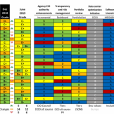
Four federal CIOs spoke at the House Oversight hearing analyzing the Federal Information Technology Acquisition Reform Act (FITARA) 8.0 scorecard. Data consolidation, outdated legacy systems and costliness dominated the conversation.

Leadership needs to find the highest impact and most valuable solutions to answer employees’ demands and allow for expansion down the road.

Dialogue is any productive conversation featuring reciprocity and mutual respect between both parties. It’s a tactic that works in and out of your agency.
Recent initiatives suggests that the federal government is more focused on strengthening the customer experience (CX) it provides than ever before.

Cyberattacks on state and local governments continue making headlines because of their detrimental consequences on constituents. At a recent House hearing, experts asked the federal government for better resources to prevent and mitigate threats.

Digital Workspaces combine cloud computing and legacy IT across multiple clouds to keep using traditional technology while adding cloud’s flexibility.
Federal agencies are moving full steam ahead with cloud adoption — backed by a suite of new policy changes aimed at removing barriers to cloud procurement, security and workforce challenges.

Key controls represent methods for managing vulnerabilities and reducing and mitigating risk. Subsequently, key controls boost cloud security for agencies.

Most agencies are accustomed to managing PDF files, Word documents and other standard text inputs. But traditional systems for managing this type of content are incapable of keeping up with the growing diversity, increasing size and the volume of unstructured content (video, audio and more) that government employees and citizens are rapidly producing.