The Importance of Real-Time Data to Your Agency
This was the topic at hand during GovLoop’s recent online training, “Agencies Put GIS to Use in Real Time.” Two experts from Esri shared knowledge.

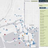
This was the topic at hand during GovLoop’s recent online training, “Agencies Put GIS to Use in Real Time.” Two experts from Esri shared knowledge.

Cities, counties and states are already leveraging the power of GIS to combat opioid crises in their communities. Read these two case studies to learn how.

Now in its 21st year, Esri’s Federal GIS (FedGIS) Conference kicks off March 20-21. Open to all federal government agency workers, this event attracts 3,000 attendees and invites all to share their experience in collaborating, innovating, and connecting their work using spatial analytics technology.
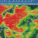
Detecting and responding to any type of infectious disease requires geographic accuracy along with the ability to track and gather data. A GIS platform allows you to visualize and analyze information layered onto a map in order to understand relationships, patterns and trends.

Rarely is spatial analysis seen as a competency that should be shared horizontally through all organizations. But hiring data scientists to lead this charge is a key piece to the puzzle of solving urban challenges.

The role of geographic information systems (GIS) is obvious in many community emergencies, like wildfires, hurricanes or flooding. Borrowing from transferable workflows and decision support tools, state and local governments are applying these best practices to battle social inequities such as blight, opioid addiction and homelessness. These similarities do require a shift in organizational andRead… Read more »

The advent of spatial technology has automated spatial problem solving. As a result, we are seeing a rebirth in the age of discovery.

The 4th Industrial Revolution can be described through current and developing systems as disruptive technologies such as robotics and drones, virtual reality and artificial intelligence and how they will change the way we work and live.

What can government and smart communities learn from the flu? You’d be surprised.

Web-based GIS tools are already in use by governments and they have already proved their worth by providing citizens increased transparency and accountability. Now is the time to apply the same patterns and practices to redistricting, ultimately rebuilding trust in the process.