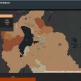
Transportation Data Reveals the 100 Greenest Metro Areas in the US
Many cities moved quickly to adjust transportation infrastructure. Your agency can use this data to gain insights for your transportation planning efforts.


Many cities moved quickly to adjust transportation infrastructure. Your agency can use this data to gain insights for your transportation planning efforts.

Traffic fatalities rose even as driving decreased in 2020, and transportation planners stepping up their safety initiatives — especially for pedestrians.

To combat the spread of an infectious disease, which requires contact tracing, geospatial information has shown what feet on the ground can’t.
The second-largest county in Utah, Utah County, transformed its outdated election processes into a location-enabled system suited for modern-day elections.

We can all recognize that the role geography plays in executing an effective public health response is critical. Understanding how to apply location-based thinking enhances preparedness and response efforts.

Operational efficiency is one of the four technology tenets of a smart community. It takes many forms, but it essentially involves developing new ways of working that enable agencies to optimize the management and performance of internal operations and constituent services. New workflows can reduce the cost of and time it takes to deliver existingRead… Read more »

Assessing property values in Crawford County, in rural northwestern Pennsylvania, is always a challenge, with only three assessors on staff to cover 51 municipalities.

The AWS partner network supports frontline workers with technology that enables tracking of health care resources, analyzes utilization of resources and more.
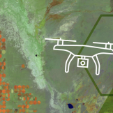
Onondaga County, N.Y., Water Authority began using drone technology to inspect its water tanks, and gathered more information faster and saved costs.

When Hurricane Matthew hit Myrtle Beach, South Carolina, it dumped 10 to 17 inches of rain and generated a storm surge that reached levels not seen since Hurricane Hugo in 1989.