Mapping out the Future: How Imagery Plays in to Government
It’s an exciting era for those in government. Vivid satellite images, airborne drones and 3D technology have unlocked another realm of possibility for public service.


It’s an exciting era for those in government. Vivid satellite images, airborne drones and 3D technology have unlocked another realm of possibility for public service.

Explore some of the questions asked on a recent online training with imagery and GIS experts.

Government is always seeking to improve the services that they provide, whether that means responding faster, cutting costs or providing more quality service. With the help of real-time GIS, each of those and more becomes possible.

Disease surveillance has long been important to preserving the health of people around the world, deterring outbreaks by monitoring the spread of disease and reacting as efficiently as possible. But what if the reaction could occur before the disease spreads at all? Geographic Information Systems (GIS) might be the key.
Learn how GIS can assist government in implementing infrastructure improvements in a data-driven and cost-effective manner.
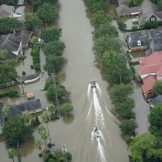
Public health preparedness staff need a collection of foundational data, supported by GIS, on an enterprise platform, that is ready to go when a disaster strikes.

Public health preparedness professionals are facing tight budgets at a time when disasters and emergencies are increasing. A recent online training discussed how organizations are using GIS to modernize their efforts.
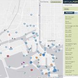
A connected government participates in the creation and maintenance of data and real-time information. They move away from creating siloed smart projects and set up a true real-time infrastructure that can ingest, collect and analyze real-time data.

In this post I am discussing geo-enabled enterprises. This spatial indexing of data not only creates a new data element to analyze but also allows the data to be visualized in a very intuitive way; as a map
This was the topic at hand during GovLoop’s recent online training, “Agencies Put GIS to Use in Real Time.” Two experts from Esri shared knowledge.