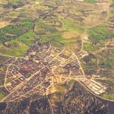
Using GIS Technology to Shrink Social Divides
Government agencies have more data at their disposal than ever before. Esri’s Christopher Thomas discussed how best to put that data to use with GIS.


Government agencies have more data at their disposal than ever before. Esri’s Christopher Thomas discussed how best to put that data to use with GIS.

Teaching students to think spatially is but one of the elements, an important one from my point of view, that our policy leaders at the local, state, and national levels must work on.

There is no doubt that this is a crisis; a true state of emergency. Lots is being done, but there is room to do more. We need to put a face to this crisis.

As roads deteriorate and highway fatalities continue to rise, citizen satisfaction with public transportation offerings is faltering. Now more than ever, it is critical for the public sector to invest in digitized transportation.

To put a face on it is to make something seem more real or easier to understand or make something human. Let’s honor the people who served our country, paying a price that was either small, big or ultimate.
Government is often individually compartmentalizing their activity and data, but agencies don’t always have an end game in mind. In other words, they are fixing pieces, but not looking at the whole picture. GIS is the foundational piece that can connect the aspects of your smart community and help you topple silos, think holistically and… Read more »

What’s at the heart of solving some of our nation’s biggest issues like poverty, homelessness and drug addiction? The answer lies in data.

Each year, government agencies lose billions of dollars due to fraud, waste and abuse. Government agencies tasked with fraud prevention are increasingly turning to geographic information system (GIS) platforms — utilizing maps, geo-enrichment and sophisticated data analytics — to tackle fraud, accurately identify patterns and problem areas and improve organizational efficiency.

If you work for a state or local government, you probably know how hard it is to plan for winter. Esri, a leading GIS company, might have a solution.
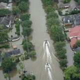
In one of the costliest hurricane seasons ever for the mainland United States, GIS mapping has emerged as a potentially life-saving tool.