Day 3
Staff Meeting
Today started off with a staff meeting for the engineering division. Normally in our meetings we discuss the status of projects and developments. Today we also discussed engineering policies for our division. Many of the other departments in the city are documenting the policies, processes, and work flows by which their department functions. So I thought it would be a good idea to develop this guidance for our division. We have started out with a working document that lists many but not all of the policies we already follow. Now we will incorporate the discussion points we brought up today and add some more of the policies suggested by the group. I think it was a good start and worth the time we took to review the document.
Frames and Grates for Road Project
I also worked on finalizing the frames and grates we will use for that one set of structures on our road project I mentioned in an earlier post. The idea is to replace the existing frames and grates with ones that better fit the structures. This will decrease the potential for failure of the pavement in the future. The sales person for EJIW did a great job picking out a frame and grate that would work. And once I verified it was what we wanted, I ordered them for the project.
Establishing Horizontal and Vertical Control Points
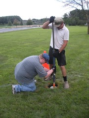
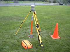
Around lunch time, I spoke with and inspected the work we had arranged to have done to set a permanent horizontal and vertical control point on the property at public works. (The type of monument set is a Berntsen monument.) This is the culmination of much research related to how benchmarks should be handled. In the “old days” we would have ran a series of benchmark circuits and set up a network of benchmarks throughout the city. With GPS, the method of handling benchmarks is evolving to a different type of network. Instead agencies are setting up a small number of control points set to first-order precision. Then all work is performed using GPS units that reference back to these control points. We realize not everyone has the necessary GPS units, and our division does not yet have this equipment. But many companies do so we thought rather than waste money setting up a system that will be obsolete by the time it is done, it’s better to spend less money setting up a more state-of-the-art system that will better support future practices. As for us, we decided we only need a benchmark referenced to USGS datum about once a year. So it’s cheaper to hire someone to set a localized benchmark for that one time a year. For the rest of our work, we only use a project-based datum. The photos in the post show the monument that was set.
Personnel
I sat in on a personnel discussion for a position we have open in our water/sewer department.
Property Research and Bike Trails
A couple of us went over to city hall to meet with other staff about property and how it relates to a bike trail we would like to construct. We reviewed documents and research others did in the past and discussed possible alternatives to constructing the path.
Miscellaneous
The rest of the day was filled with miscellaneous tasks related to the sealcoating project, development of our GIS street centerline layer, and discussion of ownership of the pond in the subdivision I mentioned in past posts.


Leave a Reply
You must be logged in to post a comment.