The 2017/2018 flu season has government agencies throughout the United States working overtime dealing with a particularly brutal epidemic. Many of these agencies rely heavily on a geographic information system (GIS), using GIS technology to help safeguard public health and wellness, and to mitigate existing and potential epidemics.
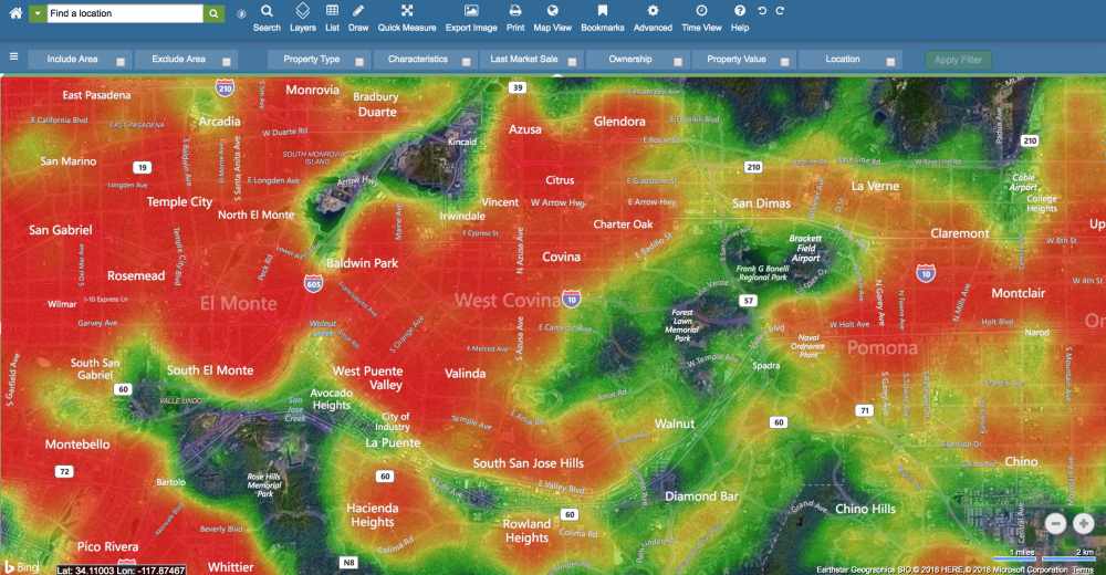
So what does GIS technology have to do with the flu? Detecting and responding to any type of infectious disease requires geographic accuracy along with the ability to track and gather data. A GIS platform allows you to visualize and analyze information layered onto a map in order to understand relationships, patterns and trends. When it comes to infectious disease, a GIS platform can help public health officials in a number of ways, including:
- View visual spread of disease over a particular population
- View spread of disease over a certain period of time
- Location of emergency and public health services in relation to the overall population
- Whether proximity of public health services helps to stop or slow the spread of epidemics
- Communicating critical information to citizens
In the immediate moment, a spatial view of a community paired with public health data offers easier analysis of the existing situation, and can provide a predictive model of where epidemics could spread and where people can turn for help. In planning for the future, spatial analysis can review the overall response to a public health crisis and modify certain elements to mitigate severity of future outbreaks.
Situational Awareness
Public health officials begin investigation as soon as flu cases are being reported at the start of flu season. Pairing data collection with digital mapping strengthens management and analysis of information by allowing officials to easily visualize the geographic progression of outbreaks. Public health officials using GIS can continually evaluate the severity of disease against the status of existing resources, which offers insight into how effective the response will be. For example, officials using GIS paired with public health data can quickly identify areas of greatest population density, and they can see when disease is likely to hit those areas. This allows them to give priority resources for those vulnerable areas to prevent and control outbreaks as much as possible.
Gathering and Analyzing Public Health Data
A strong GIS platform should support importing any type of location data government agencies want to analyze. When government works together with public health agencies and doctors offices, georeferencing the data they gather could reveal powerful insights on detection and surveillance to effectively respond to epidemics and gain knowledge as to what resources could be required to combat future epidemics.
Maps of disease location and severity could help to more easily identify vulnerable populations and determine who is at greatest risk. A GIS platform should contain accurate information on population density, location of pharmacies, doctors, hospitals and emergency services, as well as drive times to these services. It should also provide accurate address and ownership information, making it easy to contact constituents when necessary.
For example, here are survey questions that could be distributed to various communities within your jurisdiction to assist in better understanding and combating flu epidemics:
- Are you aware that the CDC recommends annual flu shots?
- Did you get a flu vaccine?
- Have you ever gotten a flu vaccine?
- Did everyone in your home get a flu vaccine?
- If you’ve never gotten a flu vaccine, what is the reason you choose to opt out?
- Did you have to visit the doctor or emergency room due to illness?
- What crowded venues do you frequently visit? (ie grocery store, shopping center, restaurant)
The answers to the survey questions above paired with spatial data, can help government agencies understand what resources are needed and where they are needed most. These can include education on flu shots, education on what to do if you have the flu, popup clinics offering vaccines, extra sanitation services in highly populated areas during flu season, and materials for employers and schools to help prevent epidemics from spreading.
Sharing Data Between Jurisdictions
Efforts to respond to and contain infectious disease are more effective when different jurisdictions are able rapidly communicate and share information. A GIS platform should facilitate this communication by making it easy to import information received from other jurisdictions, analyze it, and then communicate findings internally, and to other government offices and constituents. Various data points should be approved, and uniform templates can be created to develop more efficient collaboration. This form of communication can alert jurisdictions about whether disease is spreading, how quickly it’s spreading, where it’s peaking, and whether clinics and hospitals are overwhelmed.
Communicating to Constituents
Educating constituents is critical in responding to and containing the spread of flu as much as possible, and a GIS platform should offer a portal that easily interfaces with your community. Information empowers your community to take necessary actions to stay as safe as possible, including:
- Location of hospitals, doctors offices, and urgent care clinics
- Locations offering flu shots
- Explanation of the importance of receiving flu shots
- An explanation of flu symptoms
- What to do if you think you have the flu
- Steps people should take to prevent catching the flu
- A map-based projection of when and where flu is expected to hit hardest
- Updates on vaccine or antiviral shortages
- The ability to report on whether individual constituents have been diagnosed with flu
Public knowledge and education is a huge piece in helping to prevent the spread of disease, making easy communication critical for government agencies. This information can be shared with media to help spread reliable information as quickly as possible.
Preparedness for Future Epidemics
Data tracked and analyzed through the duration of a flu epidemic using GIS helps government agencies develop insights to be better prepared for future epidemics. This includes an assessment of regional and statewide distribution of hospital supplies, staff, and medication in relation to populations hit the hardest, and how quickly those resources are depleted. Government health care agencies can accordingly develop data-backed budgets and strategies for flu control and prevention.
What Government Agencies Should Look for in a GIS Platform:
Your GIS platform should offer tools that are specific to the unique needs and requirements of government agencies. Here are important features you should look for if you’re considering onboarding a GIS platform to help track and manage public health and wellness:
- Supports varying levels of GIS knowledge/experience: Your GIS platform should be easy for a novice user to pick up the basics fairly quickly, but advanced enough to support the work of GIS scientists on your team.
- Supports data importation: Data importation should be a simple and seamless process. Be sure you can import data on your own or with help from your platform’s customer support team.
- Supports interdepartmental collaboration: All departments should have easy access to the GIS information they need. Your GIS platform should also support the ability to create powerful map-based visuals for use in reports and presentations developed for colleagues who do not use your GIS platform.
- Visual data displays: It’s easier to analyze and communicate complex spatial information to colleagues, constituents, and laymen when it’s presented visually, layered
onto a map. Be sure your platform presents information in a way that’s easy for everyone to understand. - Portal to communicate and share information with constituents: Transparency of information is critical in helping constituents develop trust for their government agencies. A GIS platform should provide an easy way to communicate the information constituents need to see, as well as a provide a space that supports open dialogue.
- Data is accurate and is continually updated: It’s important to ensure the GIS platform you’re using is continually updating data. Data changes quickly, and using outdated information will reduce efficacy of plans and decision making.
The actionable data offered by GIS technology and its ability to help state and local government agencies create and develop stronger human health initiatives extends well beyond managing the flu. GIS provides a platform to effectively track and manage all spatially relevant information when it comes to health and human services. When layering the appropriate data over various populations, unique insights and solutions can be revealed concerning the nation’s opioid crisis, homelessness, foodborne illness, and so much more. Using GIS to help combat some of our nation’s biggest problems will promote gains in accuracy, effectiveness, resource tracking, and even cost savings.
Author Bio

Tracie Wilson is the National Director – Government Solutions at Digital Map Products. She is passionate about using her technology and government experience to help cities, states and federal agencies provide valuable solutions to their constituents.


Leave a Reply
You must be logged in to post a comment.