It’s a formidable challenge. Deliver human services to nearly 2.5 million people across the 7,000-square-mile expanse of Riverside County, California — and do it effectively and efficiently.
From bustling urban centers to remote desert locales, the county’s needs are as varied as its geography. To meet those diverse needs, county officials recently adopted an integrated services delivery model.
Their objectives include identifying gaps in health care, housing, and social services to vulnerable populations, and connecting communities with the resources they needed. At the center of this approach is a data hub powered by geographic information system (GIS) technology.
Developing a Model Focused on People
Before the new service delivery model, accessing Riverside County services was often a complicated paperwork-driven process involving disconnected county departments and requiring in-person visits — a challenge for those who didn’t live nearby.
Making the process more efficient would require a complete rethinking.
Darryl Polk, Chief Technology Officer of Riverside County, noted two factors often kept people from taking action that could improve outcomes: a reliance on “the way things had always been done” and bureaucratic systems within the county.
For a new integrated services delivery pilot, the county committed to building a people-centric model. The focus would be on the seamless integration of services to enhance the quality of life for the most vulnerable residents. It would aim to streamline service delivery for effectiveness and reduce inefficiencies.
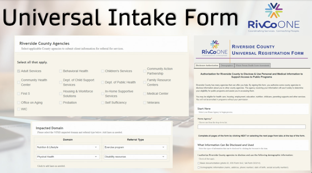
That seamless integration began with a single intake form to share information across departments. This means residents can apply for all available resources in one place with a single form.

“Our mentality was to ensure that we had the correct mechanisms in place to always get the people the most services they can get with no wrong door,” said Polk. The form, a product of extensive collaboration across 17 departments and legal review, symbolizes the county’s promise for a more integrated and people-centric service model.
A Geospatial Approach to Service Delivery
To reach this goal of improving services for its most at-risk communities the county took a geographic approach with GIS as the foundation.
“We have 28 cities with widely divergent community needs — some of the most affluent and some of the most in need. Location was one of our first considerations,” Polk continued.
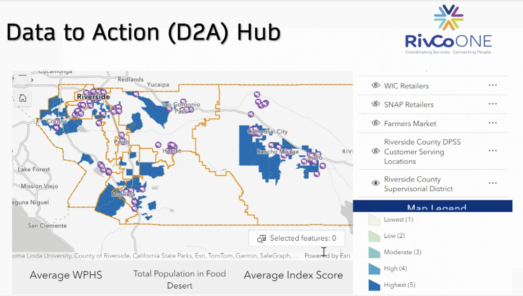
As part of the pilot, Polk’s team used ArcGIS Hub to identify households that were underutilizing benefits from programs including the Supplemental Nutrition Assistance Program, CalFresh, and the Women, Infants, and Children Nutrition Program.
“We wanted to figure out where there were families out there that were eligible but weren’t consuming it,” said Polk
ArcGIS Hub is an easy-to-configure community interaction tool that organizes people, data, and tools through information-driven initiatives. Polk’s team, with help from Esri Services, used ArcGIS Hub to create the Data to Action (D2A) Hub. They combined income and demographic data with information about Riverside County service participants and relevant food assistance programs.

With all relevant data on one map, they could clearly identify communities most likely to benefit from pop-up clinics. They could even drill down from the census block to the household level.
“This gave us insights into where we could be most impactful, so we could focus our efforts to move quickly and efficiently,” Polk said.
Based on insights from GIS, Riverside County successfully piloted seven pop-up clinics. The clinics provide comprehensive services including medical care, mental health support, job assistance, and food security — all tailored to the individual needs identified through GIS analysis. Now that the accessibility gap has been bridged, more residents can receive the resources they need.
Since launching the D2A Hub, Polk’s team has leveraged ArcGIS Hub to develop other strategic hubs. For example, they have created a hub and index for the Riverside Community Assets and Needs program, a hub for homelessness, and a hub called Lean Learning (a repository for all the county’s process improvements).
Piloting Success and Looking to the Future
Riverside County’s integrated services pilot program has shown promising results. Within 18 months of implementation, 90 percent of participants rated their experience as satisfactory or better. Additionally, 95 percent of participants shared their contact information with other agencies, demonstrating the effectiveness of this new approach. The adoption rate of the program stands at 99 percent, indicating strong acceptance and appreciation from the community.
Soon, Polk’s team plans to add more clinics and outreach to vulnerable groups including unhoused veterans with disabilities, the elderly, and at-risk children. The county also plans to expand its data-sharing program across all 48 departments. This strategic move will break down data silos and improve coordination across sectors like healthcare, social services, and housing.
Christopher Thomas is the director of government markets at Esri and a founding team member of the Industry Marketing Department. Prior to joining Esri in 1997, he was the first GIS coordinator for the City of Ontario, California. Thomas frequently writes articles on the use of GIS by government.
To learn more about how to deliver improved health and human services with GIS, visit esri.com/en-us/industries/health/overview.


Leave a Reply
You must be logged in to post a comment.