Known as the “Music City” and a hub for healthcare — including Oracle’s new headquarters—Nashville, Tennessee, is thriving. In 2023, the city welcomed an average of 86 new residents daily and saw a record-breaking 16.8 million tourists. Nashville’s growth has led to important urban projects, like the East Bank development which will transform 550 acres of mostly asphalt parking into a lively urban district.
Leaders with the Metropolitan Government of Nashville and Davidson County, otherwise known as Metro Nashville, found a way to stay ahead of these rapid changes. Their approach includes leveraging modern technologies on an enterprise scale. Specifically, they expanded the use of geographic information system (GIS) technology to improve services, collaboration, and efficiency across all departments.
Today, more than 60 Metro Nashville departments and agencies rely on the city’s enterprise-wide geospatial platform to create, manage, analyze, map, and share all types of data.
- The Metropolitan Beer Permit Board maps locations of repeated violations for underage drinking. Staff combined data from their permitting system to identify patterns, especially near schools and places teens frequent.
- The Nashville Water Services Department maps all the fire hydrants and water connections in the city. This map was shared during city event planning sessions to ensure access to those during an emergency.
- After a tornado hit Nashville, Metro Nashville Information Technology Services, Office of Emergency staff and a nonprofit teamed up. They used damage assessments and smart maps to aid families most in need.
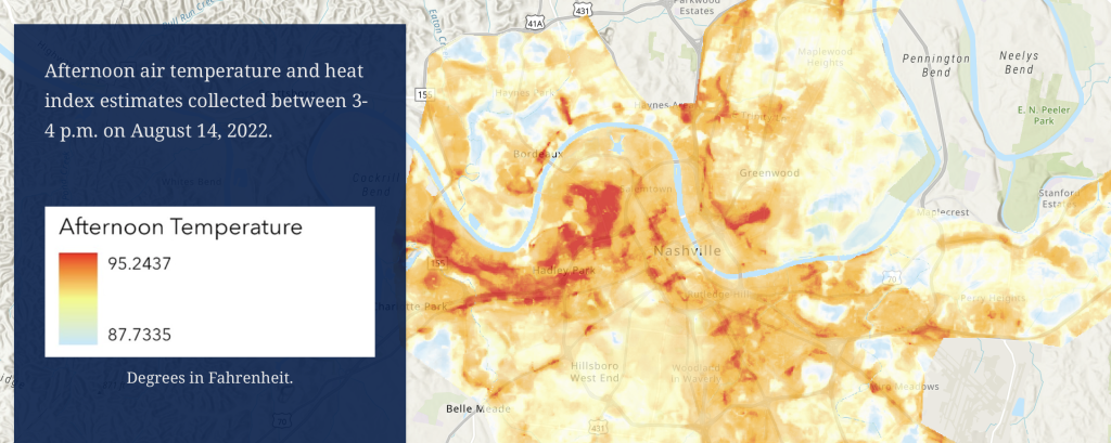
- The Nashville Heat Mapping Campaign brought together multiple state and local organizations, including universities, to identify regions with heat-related vulnerabilities. This information was mapped and shared in a digital story.
The city’s Information Technology Services Department (ITS) led Metro Nashville’s transition from using GIS in a single department — the planning department — to expanding it to an enterprise operation. This change was supported by robust technology governance and executive buy-in.

From Planning to Everything
Originally, GIS gave Nashville’s planning department a way to provide critical data for urban planning. As the city evolved, the department handled other various map requests, including parcel information, flood maps, and development tracking. But after thirty years, and with the hiring of a new executive director in 2018, the limitations of keeping geospatial capabilities within a single department became apparent. They needed to scale and make the benefits more accessible across departments.
“GIS was already recognized as an essential tool across Metro [Nashville], and we had key elements in place at that time, such as our enterprise geodatabase,” said Colleen Herndon, ITS assistant director. “However, what we lacked was that truly expandable architecture that was necessary to grow our GIS program at the enterprise scale.”
City leaders wanted to create an authoritative system that easily supported enterprise-wide adoption.
ITS and Planning Department staff worked together to create a memorandum of understanding (MOU) that started with an enterprise inventory of GIS data assets, applications, and licenses throughout Metro Nashville. This assessment demonstrated that an enterprise GIS platform would provide financial, resource, and operational efficiencies. The MOU outlined the goals and service expectations associated with transitioning Metro’s GIS program to ITS.
One of the first tasks the enterprise GIS team undertook was the establishment of an enterprise governance working group. Comprised of a dozen Metro Nashville departments that were regular GIS users, the working group’s members developed an enterprise governance plan to ensure data integrity, system reliability, and outline processes for system upgrades and enhancements. The structure allowed for compliance monitoring, enforcement, and updates. Centralized governance empowers ITS staff to efficiently manage portals and servers, easily giving departments access to accurate data. This collaborative approach also ensured that services were aligned with departmental needs and overall city goals.
Now, the new enterprise GIS guarantees that geospatial resources are robust, scalable, and secure, capable of supporting the city’s expanding needs.
“We didn’t just check the box on this one; we had the right people involved,” Herndon said.
The system operates across more than 115 servers, with five separate Web GIS portals: central, police, health and fire, water, and one for the Community Asset & Land Use program. Each portal was designed to accommodate varying data sensitivity requirements for each agency. The architecture also addresses problems with vendor data, internal data sharing, and asset updates.
Strategic Growth, Strategic IT
“To grow our GIS program at an enterprise level, we knew it was going to be important to instill those GIS skillsets across departments,” said Herndon.
Regular training sessions focused on the most requested GIS tools to enhance user proficiency and confidence across departments. ITS also assisted in recruiting candidates for dual roles by aiding in writing job descriptions and participating in interview panels with partner departments. Lastly, planning meetings were held between ITS and 20 department heads to evaluate opportunities for expanded use of GIS to support departmental goals, identify areas for efficiency gains, and gather feedback on desired features and functionality.
As Nashville grows, technology will continue to be crucial for managing urban expansion and meeting the needs of residents and businesses. By adding GIS to its enterprise tech stack, Nashville can better support critical initiatives like the East Bank development. Departments across the city will also be able to monitor and analyze data on population growth, transportation patterns, land use, and infrastructure.
“We have accomplished so much but we are just starting to scratch the surface of what’s possible,” said Herndon. “We are poised to continue expanding at an exponential rate.”
Christopher Thomas is the director of government markets at Esri and a founding team member of the Industry Marketing Department. Prior to joining Esri in 1997, he was the first GIS coordinator for the City of Ontario, California. Thomas frequently writes articles on the use of GIS by government.
Learn about the leading enterprise GIS platform used by 95% of the largest national governments, 80% of the largest cities, and 70% of the largest global companies.


Leave a Reply
You must be logged in to post a comment.