What Makes Your Community a Smart One?
The biggest developments in the smart communities movement is shifting from the idea of a single application to a series of interrelated technologies.


The biggest developments in the smart communities movement is shifting from the idea of a single application to a series of interrelated technologies.

Smart states understand that smart is a journey, not a destination, and with GIS technology they can solve current challenges.

The government needs a way to understand the complex interactions between its citizens and the environment. This is where GIS comes in.

The city government of San Diego serves 1.4 million residents by using GIS as a core technology. The city adopted GIS 30 years ago.

GIS presents a platform for sharing and collaboration for communities to solve problems. It’s a means of strategizing what is most important to a community.

Geographic information system (GIS) technology captures, organizes and analyzes geographic data for public servants trying to improve their communities.

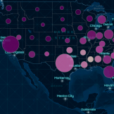
The latest advancements in GIS technology have made the work of disease surveillance efforts even more comprehensive and effective. Here’s how.

Because so many resiliency issues deal with location-based data, GIS is an essential tool for communities to use to understand and articulate where these challenges are, where they’re likely to be in coming years, as well as how and where these unforeseen issues can be either mitigated or rectified.
The future of GIS is about secure, web-based services that are accessible and put greater capabilities into the hands of everyday employees.

Two Intelligence Officers from Geollect, a company that provides advanced geospatial analysis for agencies and businesses, spoke at the Esri’s Federal GIS conference about intelligence and data science.
Notifications