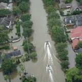
Responding to the Challenges of Public Health Preparedness With GIS
Public health preparedness staff need a collection of foundational data, supported by GIS, on an enterprise platform, that is ready to go when a disaster strikes.

Public health preparedness staff need a collection of foundational data, supported by GIS, on an enterprise platform, that is ready to go when a disaster strikes.

Public health preparedness professionals are facing tight budgets at a time when disasters and emergencies are increasing. A recent online training discussed how organizations are using GIS to modernize their efforts.
A connected government participates in the creation and maintenance of data and real-time information. They move away from creating siloed smart projects and set up a true real-time infrastructure that can ingest, collect and analyze real-time data.
This was the topic at hand during GovLoop’s recent online training, “Agencies Put GIS to Use in Real Time.” Two experts from Esri shared knowledge.

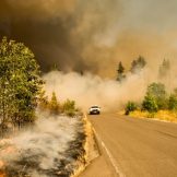
The role of geographic information systems (GIS) is obvious in many community emergencies, like wildfires, hurricanes or flooding. Borrowing from transferable workflows and decision support tools, state and local governments are applying these best practices to battle social inequities such as blight, opioid addiction and homelessness. These similarities do require a shift in organizational andRead… Read more »
Should the role of Health and Human Services professionals be elevated in the event of a natural disaster? Simple answer: Yes. And GIS can help.

Even as the opioid epidemic escalates, many government officials may not understand the true scope of the problem. But geo-enabled data and GIS mapping tools allow communities to visualize an accurate picture of how and where opioid abuse is impacting its citizens. GIS can provide a holistic picture of drug abuse, collect data in real… Read more »

Government agencies have more data at their disposal than ever before. Esri’s Christopher Thomas discussed how best to put that data to use with GIS.

Each year, government agencies lose billions of dollars due to fraud, waste and abuse. Government agencies tasked with fraud prevention are increasingly turning to geographic information system (GIS) platforms — utilizing maps, geo-enrichment and sophisticated data analytics — to tackle fraud, accurately identify patterns and problem areas and improve organizational efficiency.

If you work for a state or local government, you probably know how hard it is to plan for winter. Esri, a leading GIS company, might have a solution.
Notifications