How to Improve Your Winter Maintenance Strategy
If you work for a state or local government, you probably know how hard it is to plan for winter. Esri, a leading GIS company, might have a solution.


If you work for a state or local government, you probably know how hard it is to plan for winter. Esri, a leading GIS company, might have a solution.
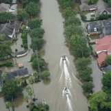
In one of the costliest hurricane seasons ever for the mainland United States, GIS mapping has emerged as a potentially life-saving tool.

Tens of thousands of U.S. citizens die from opioid overdoses every year. That’s why governments are using GIS solutions to combat the opioid epidemic with better-visualized data.

Government installations are large-scale, complex government facilities. Now the public sector is trying to take installations to the next level with smart installations. Using GIS can help.

Are you making your data meaningful and accessible?

The federal government is increasingly adopting industry best practices for earth observation and imagery workflows to improve service delivery and support the administration’s goals and other federal initiatives. At our recent event, three experts shared their takes on the ways imagery is modernizing workflows to enhance decision-making.

While mobile and GIS technology have evolved, however, they remain independent of each other in many state and local governments. Combining the two technologies can fundamentally shift the way cities, counties and states enable access to information.

The complexity of the problem can’t be overstated. Opioid addiction can have many different causes, from over-prescribing opioids for pain to improper disposal methods of unused drugs and limited treatment and rehabilitation resources. But there is a solution that can address all of these complexities as well as increase awareness and connect opioid victims to… Read more »

Many government organizations conduct field operations. Whether it is a scientist validating remotely sensed data or a National Guardsmen performing damage assessment after a hurricane, field operations staff are crucial. At our recent MapUp, Optimize Field Operations with GIS, we learned how geographic information systems (GIS) can empower those personnel to optimize their field operations.

This blog is an excerpt from GovLoop’s recent industry perspective, Creating Smart Installations With the Power of GIS. Download the full perspective here.