Informed Decision-Making Leads to Smart Infrastructure Investments
Communities need to learn to think GIS first to drive long-term decision-making and planning by implementing data-driven decisions and collaboration with geodesign.


Communities need to learn to think GIS first to drive long-term decision-making and planning by implementing data-driven decisions and collaboration with geodesign.

GIS offers exciting new ways to address some of the world’s most pressing issues.

It’s an exciting era for those in government. Vivid satellite images, airborne drones and 3D technology have unlocked another realm of possibility for public service.

Government is always seeking to improve the services that they provide, whether that means responding faster, cutting costs or providing more quality service. With the help of real-time GIS, each of those and more becomes possible.

Learn how GIS can assist government in implementing infrastructure improvements in a data-driven and cost-effective manner.
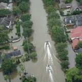
Public health preparedness staff need a collection of foundational data, supported by GIS, on an enterprise platform, that is ready to go when a disaster strikes.
A connected government participates in the creation and maintenance of data and real-time information. They move away from creating siloed smart projects and set up a true real-time infrastructure that can ingest, collect and analyze real-time data.
In this post I am discussing geo-enabled enterprises. This spatial indexing of data not only creates a new data element to analyze but also allows the data to be visualized in a very intuitive way; as a map

Cities, counties and states are already leveraging the power of GIS to combat opioid crises in their communities. Read these two case studies to learn how.
Now in its 21st year, Esri’s Federal GIS (FedGIS) Conference kicks off March 20-21. Open to all federal government agency workers, this event attracts 3,000 attendees and invites all to share their experience in collaborating, innovating, and connecting their work using spatial analytics technology.